Durham County Resources
- View All:
- Biographies
- Monuments
- locations
Copyright Notice: This article is from the Encyclopedia of North Carolina edited by William S. Powell. Copyright © 2006 by the University of North Carolina Press. Used by permission of the publisher. For personal use and not for further distribution. Please submit permission requests for other use directly to the publisher.

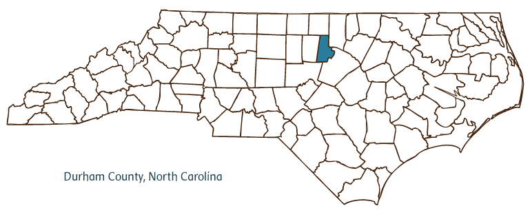
Durham County, located in the Piedmont region of central North Carolina, was formed in 1881 from Orange and Wake Counties and was named after the town of Durham, which had already been established in the area. The early inhabitants of the region included the Occaneechi and Eno Indians, followed by English, Scotch-Irish, and German settlers. Durham, the county seat, was incorporated in 1869. Other communities in Durham County include Bahama and Rougemont (and parts of Chapel Hill spill over from neighboring Orange County). Notable physical features include the Eno and Neuse Rivers, New Hope and Mountain Creeks, and Lake Michie.
Several landmarks and historic sites are situated in Durham County, including Bennett Place, scene of Confederate general Joseph E. Johnston's surrender to Union general William T. Sherman at the close of the Civil War; the Duke Homestead; Historic Stagville Plantation (1857); downtown Durham's Carolina Theatre; and West Point on the Eno, a popular 388-acre park. Duke University, established in Randolph County as Trinity College, moved to Durham in 1892; it is one of the nation's premier institutions of higher learning and a cultural and economic force within Durham County. Parrish Street in downtown Durham was the site of African American entrepreneurial activity ca. 1900 and the focal point of what became known as "Black Wall Street." North Carolina Central University (1909) is also located in the city of Durham. Other cultural institutions in the county include the Durham Arts Council, the Durham Symphony, Duke Art Museum, the Hayti Heritage Center, and the North Carolina Museum of Life and Science. Durham County hosts many annual festivals and events such as the American Dance Festival, the Festival for the Eno, the Bull City Blues Festival, the North Carolina International Jazz Festival, the North Carolina Gay and Lesbian Film Festival, and the Durham Festival of Trees.
The Research Triangle Park, home to many high-tech businesses and institutions, is located in southern Durham County and northern Wake County. The county produces agricultural goods such as tobacco, corn, soybeans, hay, wheat, barley, oats, strawberries, beef and dairy cattle, chickens, and swine, and its manufactured products include telecommunications equipment, electronic integrated circuits, fiber optics, drapes, bedspreads, and surgical instruments. The county also produces minerals such as petrified wood, hematite, pyrite, and hornblende. Durham County's population was estimated to be just under 239,000 in 2004.
For an annotated history of the county's formation, with the laws affecting the county, boundary lines and changes, and other origin information, visit these references in The Formation of the North Carolina Counties (Corbitt, 2000), available online at North Carolina Digital Collections (note, there may be additional items of interest for the county not listed here):
County formation history: https://digital.ncdcr.gov/Documents/Detail/the-formation-of-the-north-ca...
Index entry for the county: https://digital.ncdcr.gov/Documents/Detail/the-formation-of-the-north-ca...
References:
Jean Bradley Anderson, Durham County: A History of Durham County, North Carolina (1990).
Additional resources:
Corbitt, David Leroy. 2000. The formation of the North Carolina counties, 1663-1943. https://digital.ncdcr.gov/Documents/Detail/the-formation-of-the-north-carolina-counties-1663-1943/3692099?item=4553233 (accessed June 20, 2017).
Durham County Government: https://www.dconc.gov/
Greater Durham Chamber of Commerce: https://durhamchamber.org/
DigitalNC, Durham County: https://www.digitalnc.org/counties/durham-county/
Digital Durham, Duke University: http://digitaldurham.duke.edu/
North Carolina Digital Collections (explore by place, time period, format): https://digital.ncdcr.gov
Image credits:
Rudersdorf, Amy. 2010. "NC County Maps." Government & Heritage Library, State Library of North Carolina.
Powell, William S. "Durham County." NCpedia. Encyclopedia of North Carolina, University of North Carolina Press. Accessed on December 12th, 2024. http://ncpedia-02.dcs.mcnc.org/geography/durham.
DURHAM COUNTY GOVERNMENT:
https://www.dconc.gov/
COUNTY SEAT: Durham
FORMED: 1881
FORMED FROM: Orange, Wake
LAND AREA: 285.98 square miles
2020 POPULATION ESTIMATE: 324,833
White: 54.0%
Black/African American: 36.9%
American Indian: 0.9%
Asian: 5.5%
Pacific Islander: 0.1%
Two or more races: 2.6%
Hispanic/Latino: 13.7% (of any race)
From State & County QuickFacts, US Census Bureau, 2020.
CONGRESSIONAL DISTRICT: 1ST, 4TH
BIOGRAPHIES FOR![]()
Durham County
 WILDLIFE PROFILES FOR
Piedmont region
GEOGRAPHIC INFORMATION
REGION: Piedmont
RIVER BASIN: Cape Fear, Neuse, Map
NEIGHBORING COUNTIES: Chatham, Granville, Orange, Person, Wake